Sustrans and the DfT have commissioned the Institute for Transport Studies, University of Leeds to develop a tool to help identify locations for new cycleways in England.
The Rapid Cycleway Prioritisation Tool has been developed to help inform bids for Tranche 2 of the Government’s Emergency Active Travel Fund, particularly for authorities which have not yet developed Local Cycling and Walking Investment Plans.
Tranche 2 will fund temporary or permanent infrastructure schemes aimed at increasing walking and cycling levels and helping to shift people away from public transport given capacity constraints imposed by social distancing.
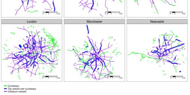
The tool provides an interactive map of the following:
– road sections that have both high demand and sufficient space for cycling (blue lines)
– existing off-road cycleways, which are often patchy (green)
– and a vision of what a joined-up cycle network could look like (purple)
Last month, under new emergency statutory guidance, the Government told councils in England to reallocate road space for walking and cycling, in response to the COVID-19 pandemic. The money has been allocated in three tranches for councils to implement the measures needed to help people walk and cycle safely.
Launching the tool in the Conversation, Robin Lovelace, associate professor in Transport Data Science, Joey Talbot, research fellow in Transport Data Science from the University of Leeds, said: “Local authorities urgently need to decide how this funding should be spent. If action is prioritised in places where there is a long-term need for cycle improvements, there is a greater chance that these developments can become permanent.
“New cycling infrastructure is more likely to be effective when it is developed based on analysis of the best available data, in combination with vital local knowledge. City planners, politicians and citizens need to act to ensure that transport interventions made during the crisis are of maximum benefit now and in the post-pandemic world.”
The research is based on open data and code and could be used in any town and city. For more information about the Rapid Cycleway Prioritisation Tool visit https://www.cyipt.bike/rapid/.
Sustrans’ Space to Move map lists all new cycling and walking schemes whilst allowing the public to share their views on them: www.sustrans.org.uk/spacetomove.
Read the latest edition of BikeBiz below: